
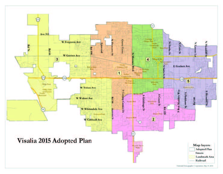
After six months of workshops, hearings and debates, the Visalia City Council finally chose a voting district map during their May 18th meeting. Out of the four maps under consideration, the city council voted to approve NDC2, drawn by professional consultant Doug Johnson. The map sets the districts until the 2020 census when the boundaries may have to be adjusted.
 The final four maps that survived several rounds of cuts by the council were heavily debated. Those four maps can be split into two groups. NDC2 and NDC3 were drawn by the National Demographics Corporation of Southern California. Map E and Map F1 were drawn by Visalia residents. Map E was drawn by former Visalia Planning Commission member, Vincent Salinas. Map F1 was submitted by the GI Forum, a Hispanic Veterans group. Robert Quiroz, a member of the GI forum, came to many of the city council meetings and hearings to support their map.
All four maps under consideration met the State and Federal Voting Rights Guidelines. But, there were two big differences; those drawn by the consulting group adjusted the district boundaries so that two council members would not be in one district. This is referred to as pairing. The community drawn maps focused on communities of interest, but both had one district shared by two incumbents.
Because none of the council members felt passionate about NDC3, the choice ultimately came down to NDC2, Map E and Map F.
Arguments in favor of maps drawn by consultant
There were strong and weak arguments for not choosing Map E and Map F1. The arguments in favor of NDC2 were spearheaded by council members Warren Gubler, Amy Shuklian, and Mayor Steve Nelsen. Gubler was the least impassioned about which map to choose saying that simplicity won him over. He said that having two candidates in one district would make it very difficult to pick who runs in 2016 and who runs in 2018. He also frowned on the accusation of Gerrymandering saying that he and Shuklian lived a mile and a half apart, so it wouldn’t be that difficult to put them into separate districts.
Nelsen said he was troubled by the fact that Vincent’s map had an island in the middle of the city. He said that the district could not expand when the city would have to adjust the boundaries after the 2020 census. NDC2 had room to grow in every district. He also was offended by the fact that the public had implied any council member would agree to a map that was gerrymandered. He said that “what is best for the city is at the heart of every decision made by all the council members. “
Because she disagreed with splitting the city into voting districts, Shuklian did not participate in the six-month process of choosing a map. May 18th was the first time she made her preference known, and it was NDC2, a map that would save her council seat. She felt that if the council chose map E or map F1 one sitting member would be eliminated from running for council again. She and Gubler also reiterated that the voters chose them, and the voters should be able to vote for them again.
During the process of drawing and narrowing down the maps, four of the council members brought up a variety of issues. Shuklian waited until the final meeting to choose a map. Though she may have been sincere in her motives, it did not go unnoticed by those who attended the meeting. She spoke out three times, and each time her opinion came back to the fact that a council member would not be able to run if Map E or Map F1 were chosen. It was no coincidence that she was talking about herself or Gubler.
Arguments in favor of choosing a community drawn map
Although Gubler pointed out that all four maps would do the job, there was a loyal contingent of the public that showed up at every hearing concerning the voting districts. They didn’t always speak but the community members were obviously not there to support a map written by a consultant who lives in Glendale. They felt that, all things being equal, then the council should consider choosing a map written by a local Hispanic.
Council member Bob Link and Greg Collins preferred the maps drawn by the community. Link said he appreciated the fact that the maps were drawn by Hispanics, in light of the fact that Hispanics were the driving force behind the change to voting districts. His preference was for F1 because he liked the way the communities were divided. Link emphasized that he did not look at who might be running for office but only took into consideration what would be best for the city.
“In five or six years it’s not going to make any difference who was sitting on the council in 2015,” he said.
Rene Lapin, Visalia resident, echoed Link’s sentiment. She pointed out that the incumbents may not even run again. She also said that, “your past voters will not vote the same way next time, and if they do, only a small sector of them will be randomly distributed throughout your new district.”
Voters may prefer a new candidate who has not yet announced his/her desire to run. Most importantly, any candidate who plans on running in 2016, isn’t getting any special consideration and neither should the sitting council, she said.
Salinas refuted the idea that one of the districts on his map was landlocked. The reality is that all the districts are landlocked by city limits and voting district boundaries. None of the five districts can jump their boundaries and grow. As the city grows, as will be seen in 2020 census, all districts will grow in population fairly equally.
Rene Lapin commented that the sudden concern with one district being “entrapped” was disingenuous and just plain silly.
“I see it as a straw man – and an excuse to choose a map that allows you to keep your seats,” she said.
James Houck, a former city editor for the Visalia Times Delta, has been involved with the process since the Voting Rights Act suit was first filed. He said that Visalia’s dirty little secret was keeping the city council election on odd numbered years so only a select group of citizens would vote. He said that may be a problem or it may not be, and that there are some council members he’d like to see on the council forever. The problem is, is that they all are trying to gerrymander the districts so that Shuklian and Gubler can keep their seats.
“If that is what you are going to do, then maybe you ought to quit right now because you are not doing your job,” he said.
Rene Lapin pointed out that gerrymandering doesn’t always mean districts turned into pretzels just to exclude or include groups of people. She said that gerrymandering “is universally understood as the redrawing of boundaries of a voting district –by incumbents –so that a group, party or official acquires an advantage at the expense of another.”
The consultant stated that drawing the districts “so no one was voted off the island” was the goal and would fit Lapin’s definition of gerrymandering.
Lapin has tried unsuccessfully to convince the city council that it is an obvious conflict of interest for incumbents to be voting on their own districts. She has been advocating for a redistricting committee to make the final decision.
Shuklian’s assertion that if the council chose Map E or Map F1, one of the council members would not be able to run for council. That is partially true. Johnson said that in the case of map E one council member would have to wait two years before they could run again.
Final decision
The final vote came to a swift and anticlimactic end as Shuklian moved to approve map NDC2. Collins seconded her motion and it passed 5-0. Although Link and Collins had each said preferred the community drawn maps, their second choice was NDC2.
Because Shuklian and Link’s at-large seats will be up next for election, the council chose their districts for the 2016 election. Districts 1 and 2, currently occupied by council members Shuklian and Link, respectively, will be up for election in 2016. Districts 3, 4 and 5, occupied by Gubler, Collins Nelsen, respectively, will be up for election in 2018.
This decision on which districts to chose for the 2016 election went against the advice of the National Demographics Corporation.
It suggested that council choose the Hispanic district for the 2016 or presidential election. Hispanics vote in greater numbers during presidential elections. District 4 currently has the highest Hispanic population in terms of total population (70% Hispanic), Hispanic citizen voting age population (57%) and Hispanic registered voters (54%).
District 4 is currently held by Greg Collins who has announced that he will not seek reelection.
A minor correction: The CA Voting Rights Act was passed way back in 2001. Former VTD editor James Houck (spelled with a “c”) was never involved in the process of election reform. He did write two critical editorials and a commentary in early 2012 when I brought to his attention that the consultant/demographer (NDC) had been hired by the city at a non-public meeting, in violation of the Brown Act.
According to universal codes of journalistic ethics employees aren’t allowed to be involved in the issues they investigate.